Gamala
site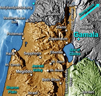
Gamala (also spelled Gamla) has been well identified with Khirbet es–Salam (also es–Sunas) that is located 3.7 mi. [6 km.] east of the northern end of the Sea of Galilee. The word “Gamala/Gamla” means “camel,” and indeed the site looks somewhat like the back of a camel. The site is large, covering about 45 acres [18.2 ha.]. It rises about 750 ft. [230 m.] above the surrounding wadis and its absolute height is 1,082 ft. [330 m.].
The site was probably first settled during the second century B.C., although coins as early as Antiochus I Soter (ca. 280 B.C.) have been found there.
During the great Jewish revolt (A.D. 66–70) the city eventually joined the rebels. After a two-stage siege, the Roman Legions breached the city wall and slaughtered the inhabitants—Josephus (see War IV) says a total of 9,000 died.
The site has been excavated and a first century (the oldest in Israel?) synagogue, a ritual bath, a round tower, portions of the city wall, houses, olive press, etc. have been discovered.
Photos (22)


